|
|
General Information
|
Forecast Tools
|
Verification
|
Related Outlooks
|
About Us
|
Contact Us
|
As of the May 19th, 2017, release, Week 3-4 outlooks precipitation outlooks are experimental, whereas the temperature outlooks are operational. Both are issued Friday between 3pm & 4pm Eastern Time.
|
|
|
HOME>
Outlook Maps>
Week 3-4 Outlooks
|
|
|
Week 3-4 Outlooks
|
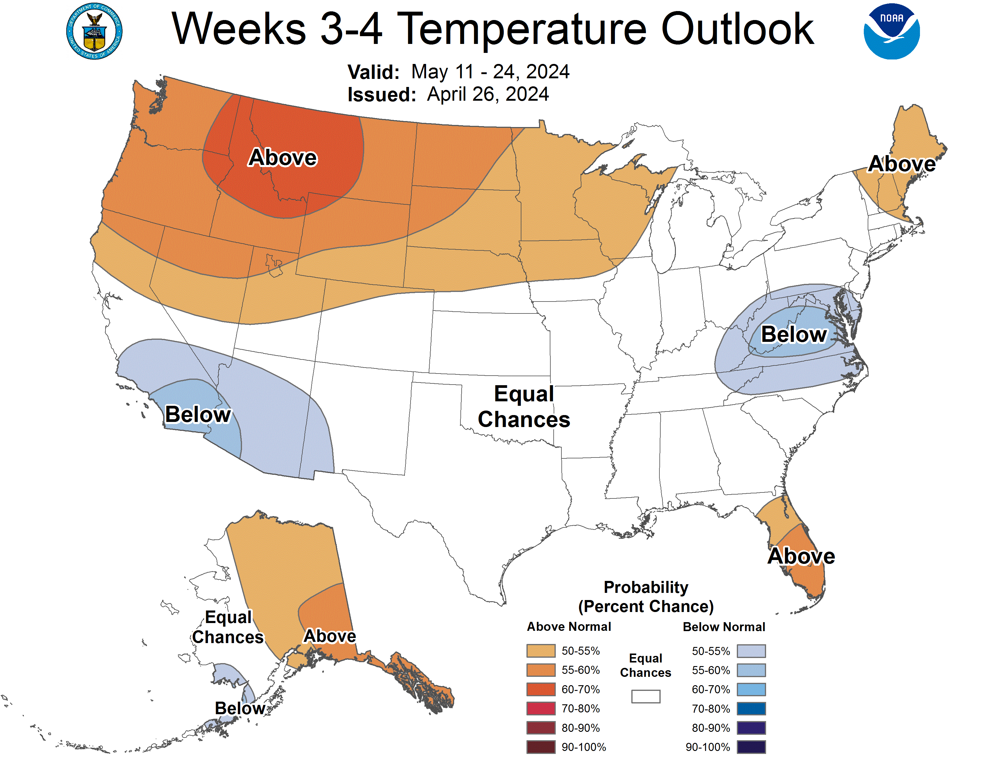
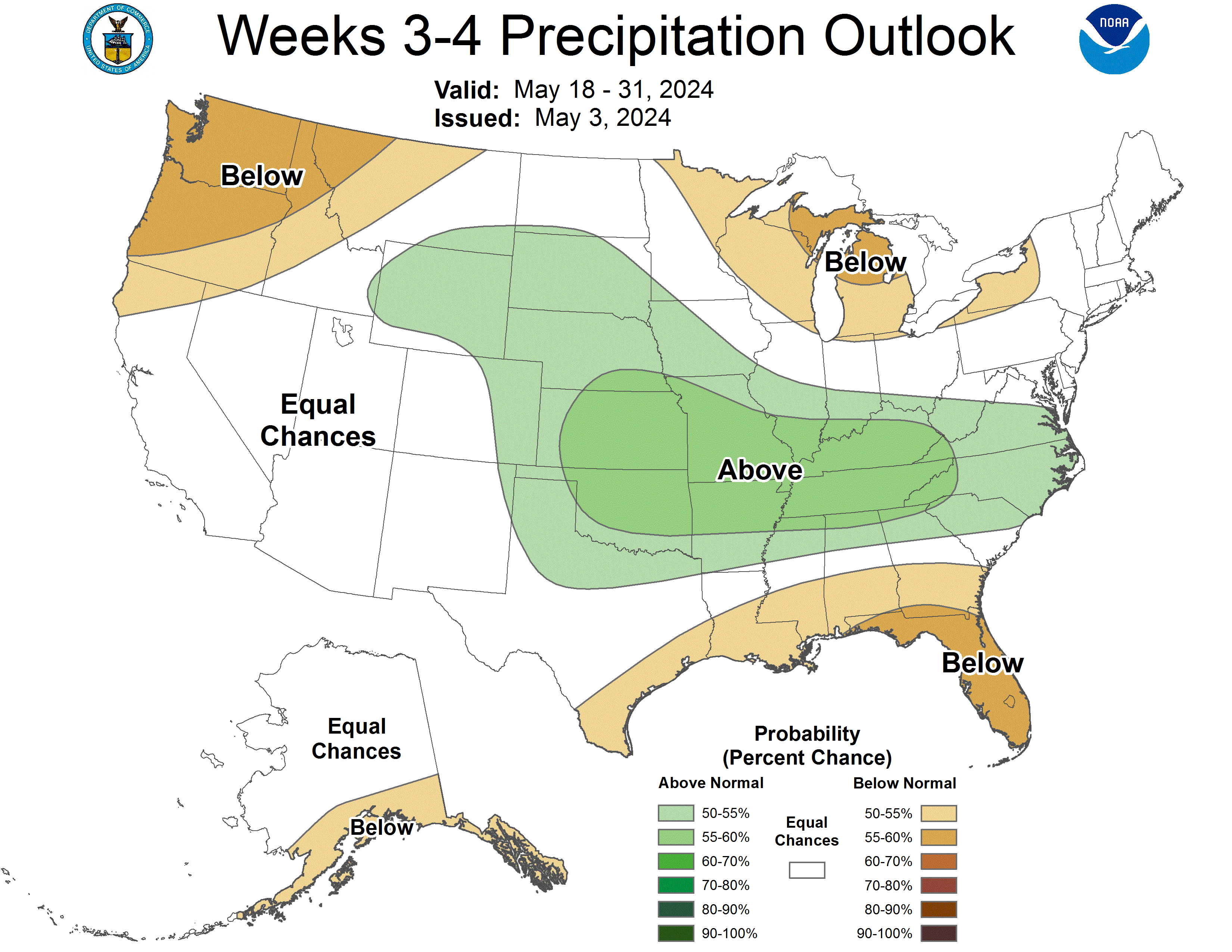
Valid: 18 May 2024 to 31 May 2024
Updated: 03 May 2024
|
|
Temperature Probability
|
Precipitation Probability
(Experimental)
|
Experimental Week 3-4 500mb Outlook
|
|
Click HERE for info about how to read Week 3-4 outlook maps
|
|
Prognostic Discussion for Week 3-4 Temperature and Experimental Precipitation Outlooks
NWS Climate Prediction Center College Park MD
300PM EDT Fri May 03 2024
Week 3-4 Forecast Discussion Valid Sat May 18 2024-Fri May 31 2024
The Weeks 3-4 Temperature and Precipitation Outlooks are for the period of May 18-31, 2024. In the tropics, El Niño continues to wane with Niño 3.4 sea surface temperatures (SST) approximately +0.75 degrees C. Sub-surface equatorial waters are anomalously cold and are beginning to emerge at the surface in the eastern Pacific. The El Niño teleconnection during May would favor troughing across the contiguous U.S. (CONUS). However, given the current rapid transition to neutral conditions, the importance of the El Niño teleconnection is quickly diminishing. The Madden-Julian Oscillation (MJO), as measured by the Real-time Multivariate MJO (RMM) indices is weakly active, with enhanced convection near the Maritime Continent, aligning with phases 4 and 5. Dynamical models favor propagation for the next week to 10 days before a general weakening of the MJO is forecast to occur. The MJO teleconnection, while not as strong during late spring as during winter, is associated with troughing in the eastern CONUS.
Other surface forcings considered for this outlook include Northern Hemisphere snow cover and soil moisture. Interestingly Northern Hemisphere snow cover is near normal for this time of year with cover still existing in the higher latitudes of Canada and Russia. This is a departure from recent years when spring snow cover has been anomalously below normal. Snow cover can dampen the diabatic surface heating that would occur if the ground were bare. Thus, pockets of cool air are expected to continue to roam through the Northern Hemisphere flow into late May. With respect to soil moisture, the greatest negative departures currently reside along the Rio Grande Valley in Texas and in the Tennessee River Valley. Most other regions are near normal or above. Significant precipitation is forecast in the Tennessee River Valley during the next week, while the Rio Grande Valley is expected to remain relatively dry.
Regarding the extratropical teleconnections, the Pacific North American pattern, the North Atlantic Oscillation, and the Arctic Oscillation are all expected to trend toward neutral by Week 3. Further, even if these teleconnections were amplified, their impact over CONUS during late spring is much weaker than during winter. Thus, these teleconnections were not considered to be important drivers for this outlook.
The Weeks 3-4 Temperature and Precipitation Outlooks take into account the aforementioned background forcings along with a blend of dynamical model guidance from the ECMWF, CFSv2, GEFSv12, and JMA. Overall, there is low to medium confidence for this outlook because 1) predictability in late spring is low as patterns become more transient with shortening atmospheric wavelengths, and 2) the ECMWF was an outlier compared to other model guidance, particularly during Week 4. To help resolve these concerns, the overall Week 3-4 outlook was weighted more toward the Week 3 solution of the models, the MJO teleconnection, and persistence from Week 2 into Week 3. This outlook features weak ridging in western CONUS and near to below normal heights in eastern CONUS. Over Alaska, the blend results in near zero height anomalies for the Weeks 3-4 period.
Consistent with the troughing and cyclonic flow in the East, elevated probabilities of below normal temperatures are forecast over the Mid-Mississippi River Valley to the Mid-Atlantic. Anomalous high soil moisture as a result of Week 1 precipitation should also help to reinforce cooler than normal conditions. Consistent with this cyclonic flow, an enhanced baroclinic zone is expected to be established. When coupled with above normal soil moisture anomalies, elevated probabilities of above normal precipitation are forecast from the Central Plains through the Tennessee River Valley into the mid-Atlantic. Equal Chances of above or below normal temperatures are forecast in the northern Great Lakes region where lake waters have well above normal temperatures. Below normal precipitation is favored in the Great Lakes region as northwesterly flow on the western flank of the trough would advect dry air into the region. Along the Gulf Coast, above normal temperatures are favored because the troughing in the East is forecast to be anchored farther north, Gulf of Mexico SSTs are above normal, and precipitation is expected to be below normal.
Western CONUS features above normal temperatures with the exception of the Southwest where equal chances are depicted. Some model solutions indicate weak troughing undercutting the West Coast ridge. The highest probabilities for above normal temperatures are located under the ridge in the Pacific Northwest and in southern Texas and New Mexico, consistent with low soil moisture. With respect to precipitation, most of the Southwest is arid in late May. Thus, lacking a strong signal for significant precipitation in the region, Equal Chances of above or below normal precipitation are depicted there. Under the ridge axis, below normal precipitation is anticipated in the Pacific Northwest.
In Alaska, the forecast of near zero height anomalies for much of the state are a result of strong model disagreement in the region. Thus, confidence is low. Nevertheless, odds tilt toward above normal temperatures in the North Slope due to the long term trend. Above normal temperatures are also favored in the Panhandle underneath the anomalous ridging along the western coast of North America. The southwest portion of the state is favored to be below normal where there is a small signal of northerly flow in the region. With respect to precipitation, late spring and early summer are climatological wet periods of the year. Because there is no coherent signal of a pattern favorable to precipitation, odds tilt toward below normal precipitation along the southern coast.
For Hawaii, the multi-model ensemble from the Subseasonal Experiment (SubX) shows enhanced probabilities of above normal temperatures and below normal precipitation across all of the islands.
| Temperature | Precipitation |
| FCST | FCST |
| Hilo | A60 | B55 |
| Kahului | A60 | B55 |
| Honolulu | A60 | B55 |
| Lihue | A60 | B55 |
Forecaster: Cory Baggett
The next week 3-4 outlook will be issued on Friday, May 10, 2024
These outlooks are based on departures from the 1991-2020 base period
These are two category outlooks and differ from official current three category outlooks currently used for the monthly and seasonal forecasts.
The shading on the temperature map depicts the most favored category, either above-normal (A) or below-normal (B) with the solid lines giving the probability ( >50%) of this more likely category (above or below).
The shading on the precipitation map depicts the most favored category, either above-median (A) or below-median (B) with the solid lines giving the probability ( >50%) of this more likely category (above or below).
In areas where the likelihoods of 2-week mean temperatures and accumulated precipitation amounts are similar to climatological probabilities, equal chances (EC) is indicated.
As of May 19, 2017, the temperature outlook is operational, while the precipitation outlook is still experimental
|
|
|
|
An ASCII (w/ HTML markup tags) text version of the written forecast is available.
|
|
|